Baltic Earth Working Group on the "Baltic Sea Model Intercomparison Project (BMIP)"
Baltic Sea Model Intercomparison Project (BMIP)

Proceeding from the 2nd Baltic Earth Conference in Helsingør in June 2018 the Baltic Earth project BMIP (Baltic Sea Model Intercomparison Project) has been initiated which aims at an assessment of the performance of different regional climate models in the Baltic Sea. The focus of the investigations will be on hydrographic conditions, the mean and overturning circulation as well as on selected processes like for instance salt water inflows, mixed layer depth, ice formation and upwelling events. The planned coordinated experiments will give insights into the long-term variability and basin-wide significance of conditions and processes and are a continuation of the work by Placke et al. (2018) which was presented on the 2nd Baltic Earth Conference. While their findings aimed at statistical evaluations between different model simulations and observational data in the frame of uncoordinated experiments, the envisaged extended study will be performed with uncoupled hindcast model runs using the same atmospheric forcing and river runoff.
Currently collaborations are planned between research groups from IOW (contributing with models like GETM and MOM), HZG (with ECOSMO and SCHISM), University of Hamburg (with BNSC data), SMHI (with NEMO), DMI (with HBM), and BSH. Further participants are cordially invited. A first one-day kickoff meeting will take place at IOW on 22 November 2018, 10:00-17:00.
References:
Gröger M, Placke M, Meier HEM, Börgel F, Brunnabend S-E, Dutheil C, Gräwe U, Hierony-mus M, Neumann T, Radtke H, Schimanke S, Su J, Väli G, 2022: The Baltic Sea Model In-tercomparison Project (BMIP) – a platform for model development, evaluation, and un-certainty assessment. Geosci Model Dev 15:8613–8638, https://doi.org/10.5194/gmd-15-8613-2022
Placke, M., Meier, H.E.M., Gräwe, U., Neumann, T., Frauen, C., and Liu, Y. (2018). Long-term mean circulation of the Baltic Sea as represented by various ocean circulation models. Front. Mar. Sci. 5:287, doi:10.3389/fmars.2018.00287
More than 2 years have passed since the 1st kick off meeting for the Baltic Sea Model Intercomparsion Project (BMIP) held in November 2018 at the Leibniz Institute for Baltic Sea Research, Warnemünde/Rostock. So far, a lot of work has been done to harmonize Baltic Sea modelling activities across different Institutes. Along with this, a number of BMIP conform simulations were carried out and a lot of data has been produced. Now it’s time to wrap and discuss the outline of the BMIP reference paper.
The purpose of this 2nd workshop is to give a BMIP status overview and to show you the first interesting results based on analysis done by IOW. The workshop is currently planned half a day and has to be held virtually.
The Workshop will take place on 9 April 2021 at 10:00 CET as a virtual meeting. Details will follow.
Demonstration of BMIP added Value
A typical problem in regional ocean model intercomparison studies is related to the use of different forcing data and boundary conditions. This hampers to draw clear scientific conclusions giving rise for a number speculations. Two examples are displayed below that demonstrate the added value by a coordinated protocoll as developed in BMIP.
Analysis
The two examples are sensitive to the thermal conditions and thus the forcing data is of particular importance. BMIP aims at harmonizing two of the most significant driving data for the Baltic Sea: the atmospheric forcing and runoff. Together with further protocols for output variables and frequency, averaging periods etc. BMIP will foster intermodel analysis far beyond previous approaches and lead to new insights into Baltic Sea environmental and hydrodynamical modelling. (Link to BMIP instructions)
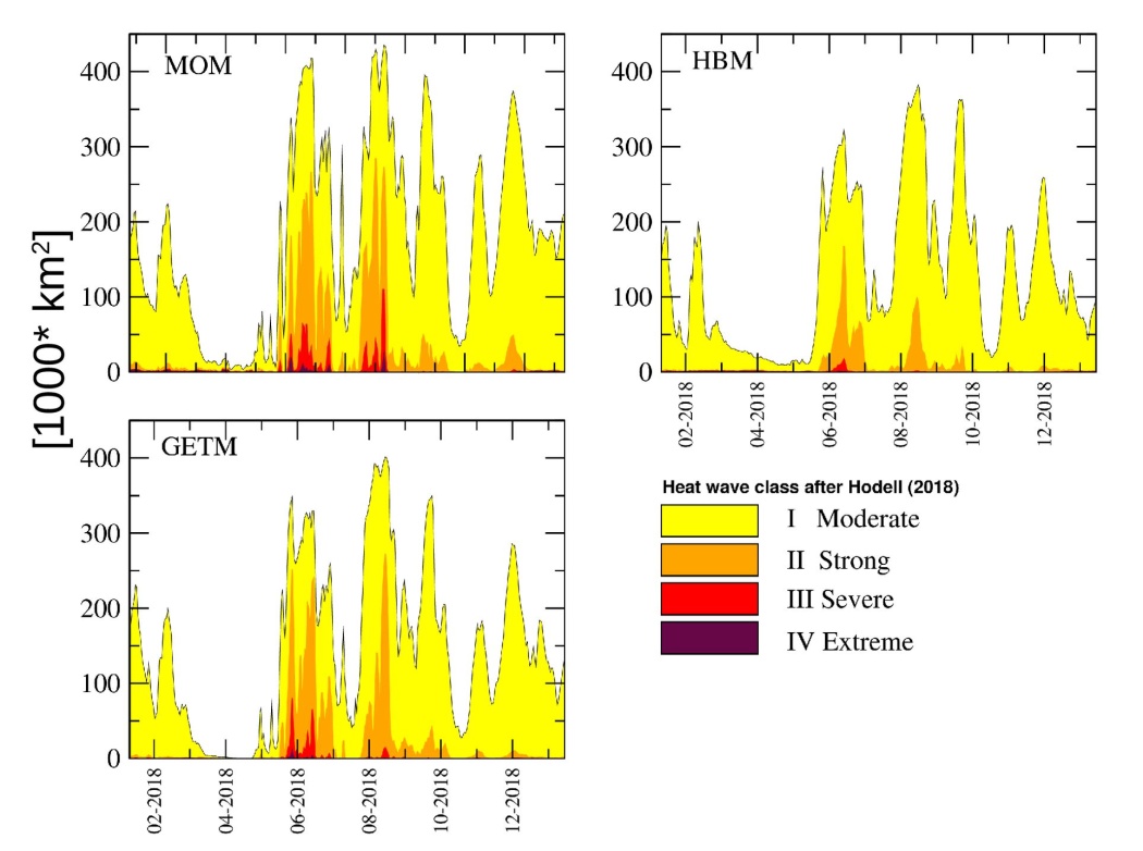
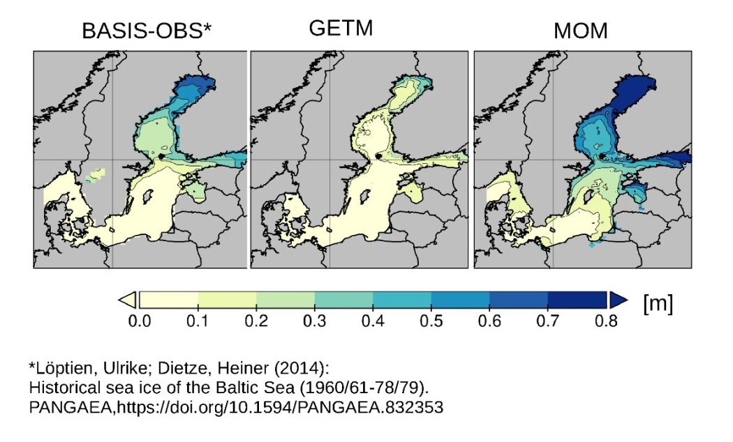
Figure a) are displays the total area covered by anomalous warm surface water together with a heat wave classification based on Hodges et al. (2018). While the rough evolution is quite consistent across the models but careful analysis reveals differences in the timing and in particular in the magnitude of the wave. Figure b) compares the yearly maximum sea ice thickness averaged over 1961-1979 simulated by two models and derived from an observation based data set. One model systematically overestimates sea ice while the other underestimates it.
Analysis by M. Gröger, IOW
The movie shows the development of the 2018 heat wave during July/August in the Baltic Sea. Displayed is the area classified heat wave strength after Hobday et al., 2018). >1 moderate HW; >2 strong HW, >3 severe HW, >4 extreme HW.
Hobday, A., Oliver, E., Sen Gupta, A., Benthuysen, J., Burrows, M., Donat, M., … Smale, D. (2018). Categorizing and Naming Marine Heatwaves. Oceanography, 31(2), 477–486. https://doi.org/10.5670/oceanog.2018.205
TOPIC 1: Welcome – Purpose of the meeting and short wrap up of activities and achievements.
(Matthias Gröger/ Markus Meier)
TOPIC 2: UERRA data set generation and validation (S. Schimanke)
TOPIC 3: Results of topical analysis for the GMD paper (~10 minutes each)
a) Sea ice (Matthias Gröger)
b) Marine heat wave 2018 (Matthias Gröger, IOW)
c) Stratification (Hagen Radtke, Germo Väli)
d) Upwelling (Cyril Dutheil, IOW)
e) Deep salinity dynamics (Florian Börgel)
f) Sea level dynamics (Ulf Gräwe)
TOPIC 4: Discussion about results in the context of the BMIP reference paper in GMD paper
TOPIC 5: Validation data for BMIP (Discussion lead by Markus Meier)
TOPIC 6: Next Steps
To follow...
Location:
Leibniz Institute for Baltic Sea Research Warnemünde,
Conference room villa,
Seestraße 15,
D-18119 Rostock
Accommodation (if required)
A small contingent of rooms (50 EUR per night including breakfast) is reserved at
Hotel "Am Alten Strom"
Am Strom 60/61
18119 Warnemünde (Rostock)
Please book your room via phone call (+49 381 54 82 31 02) or email (karen.neumann@hotel-am-alten-strom.de) with the code: IOW BMIP.
| Lars Arneborg | SMHI | Sweden | lars.arneborg@smhi.se |
| Florian Börgel | IOW | Germany | florian.boergel@iowarnemuende.de |
| Ute Däwel | HZG | Germany | ute.daewel@hzg.de |
| Christian Dieterich | SMHI | Sweden | christian.dieterich@smhi.se |
| Ulf Gräwe | IOW | Germany | ulf.graewe@io-warnemuende.de |
| Matthias Gröger | SMHI | Sweden | matthias.groger@smhi.se |
| Iris Hinrichs | UHH | Germany | iris.hinrichs@uni-hamburg.de |
| Jaromir Jakacki | IO-PAN | Poland | jjakacki@iopan.pl |
| Frank Janssen | BSH | Germany | Frank.Janssen@bsh.de |
| Ye Liu | SMHI | Sweden | ye.liu@smhi.se |
| Markus Meier | IOW, SMHI | Germany, Sweden | markus.meier@iowarnemuende.de |
| Thomas Neumann | IOW | Germany | thomas.neumann@io-warnemuende.de |
| Manja Placke | IOW | Germany | manja.placke@io-warnemuende.de |
| Corinna Schrum | HZG | Germany | Corinna.Schrum@hzg.de |
| Emil Stanev | HZG | Germany | emil.stanev@hzg.de |
| Jian Su | DMI | Denmark | jis@dmi.dk |
Institute abbreviations:
BSH (Bundesamt für Seeschifffahrt und Hydrographie)
DMI (Danish Meteorological Institute)
HZG (Helmholtz-Zentrum Geesthacht)
IOW (Leibniz Institute for Baltic Sea Research Warnemünde)
IO-PAN (Institute of Oceanology, Polish Adademy of Sciences)
SMHI (Swedish Meteorological and Hydrological Institute)
UHH (Universität Hamburg)
| optional 21 Nov 2018 |
Arrival in Warnemünde / at IOW Maybe: Informal icebreaker at a nice restaurant in Warnemünde Overnight stay at Hotel "Am Alten Strom" |
|
| 22 Nov 2018 | BMIP Kickoff Workshop at IOW | |
| 09:30 – 10:00 | Arrival at IOW, Coffee/Tea | |
| 10:00 – 10:15 | Welcome by Manja and Markus (Overview of the current status and planned coordinated experiments) |
|
| 10:15 – 11:00 | Introduction into the Baltic Sea setups of MOM, GETM, NEMO, HBM, SCHISM, ECOSMO, etc. and present status | |
| 11:00 – 12:00 | Project draft (Discussion about ideas/goals of all participants) |
|
| 12:00 – 13:00 | Lunch at IOW | |
| 13:00 – 15:00 | Animating the project (Determination of required output data and formats) |
|
| 15:00 – 15:15 | Coffee & tea break | |
| 15:15 – 16:15 | Agreement on data processing | |
| 16:15 – 17:00 | Project fixation (Final discussions and summary of defined decisions) |
|
| 17:00 | End of the workshop, Departure | |
| optional | Overnight stay at Hotel "Am Alten Strom" and departure on 23 Nov 2018 |
Setup for all involved models: For a convenient data handling, arrangements will be made to ensure a uniform data output and structure. It is aspired that the individual modeling groups post-process their data themselves (e.g., interpolation on a regular grid) in order to avoid wrong data handling.
| Horizontal resolution | 2 nm |
| Vertical resolution | 3 m |
| Temporal resolution | monthly means of all 3D variables; daily time series of T, S, u, v at representative stations and depths, e.g., as in Placke et al. 2018: Stations: - BY2 in the Arkona Basin (55.0°N, 14.1°E), - BY5 at Bornholm Deep (55.3°N, 16.0°E), - BY15 at Gotland Deep (57.3°N, 20.0°E), - LL7 in the Gulf of Finland (59.9°N, 24.8°E), - SR5 in the Bothnian Sea (61.1°N, 19.6°E), and - F9 in the Bothnian Bay (64.7°N, 22.1°E) Depths: 0, 15, 30, 60, 80, 125, 200, 225 m |
| Region | North and Baltic Sea with focus on the Baltic Sea |
| Boundary conditions | water level observations in Kattegat (optional RCO boundary conditions) |
| Baltic Sea topography | can be provided by IOW on demand |
| Atmospheric forcing | UERRA data provided by SMHI (temporal coverage: 1961-2017/18) - UERRA project website: http://www.uerra.eu/ - UERRA website at ECMWF with link to data portal: https://software.ecmwf.int/wiki/display/UER -SMHI UERRA data can be found under HARMONIE/V1 |
| Runoff | will be provided by IOW |
No exchange of 3D fields! Only post-processed data.
| Planned data output | Description | Unit |
| Model grid (lat, lon, dep, dx, dy, dz) |
latitude, longitude depth, grid cell dimensions |
[degree] [m] |
| Temperature (T) | [degree Celsius] | |
| Salinity (S) | [g kg–1] | |
| Current velocity (u, v) | in zonal and meridional direction | [m s–1] |
| Overturning circulation (oc) | Zonal/meridional integration of volume transport at each latitude/longitude and depth and subsequent depth integration from bottom towards surface | [m3 s–1] |
| Mixed layer depth (mld) | [m] | |
| Maximum annual ice extent (ice) | Regarding grid cells filled with >=10% ice |
[km3] |
| Sea-ice thickness (di) | [m] |
Participating institutions


