Baltic Earth Newsletter
The Baltic EarthNewsletter is intended to be published 2-4 times a year. It contains news, information, announcements of meetings and events around Baltic Earth as well as scientific articles related to the Baltic Earth Grand Challenges. You can send an article anytime to the IBES at balticearth(at)hzg.de.
It is hoped that the Baltic Earth Newsletter may be widely and regularly used for information on results of running and past projects and studies, as well as ideas and plans for future research.
As of No. 2, the Newsletter is in e-mail format and a pdf is provided here as well.
24 - 25 October, 2017, Gothenburg, Sweden

Solas Sheba Conference
by Anna Rutgersson, Uppsala University, Sweden (anna.rutgersson@met.uu.se>)
Given its importance for the transport of goods on a global scale, there is a growing interest on the sustainability of the shipping industry. Shipping is a very carbon-efficient transport medium, but there is an increasing focus on its broader environmental consequences. The science for a better future of the Baltic Sea region (BONUS) and the Sustainable Shipping and Environment of the Baltic Sea region (SHEBA) project address a wide range of environmental impacts of shipping in the Baltic Sea including air pollution, marine pollution, underwater noise and climate change, as well as the socio-economic consequences of these impacts.
The International Surface Ocean - Lower Atmosphere Study (SOLAS) project is an international research initiative aiming to understand the key biogeochemical-physical interactions and feedbacks between the ocean and atmosphere. Achievement of this goal is important to understand and quantify the role that ocean-atmosphere interactions play in the regulation of climate and global change. With increasing focus on science and society, increase attention on shipping is given within SOLAS.
SOLAS and SHEBA joined forces to organise a two-day conference “Shipping and the Environment - From Regional to Global Perspectives” , which was held at the University of Gothenburg’s conference centre on 24-25 October 2017, and attracted 117 participants from 15 countries.
The conference programme was divided into five sessions with wide interdisciplinary coverage: Atmospheric processes; assessments of integrated effects on environment and climate; marine processes; noise; socioeconomic aspects and policies. Each session included both oral and poster presentations. The oral presentations were followed by a panel discussion between researchers and stakeholders. A joint special issue in the journals Atmospheric Chemistry and Physics, and Ocean Science will provide a platform for disseminating the new research presented at the conference. Several participants noted with pleasure that this was the first international conference addressing the environmental consequences of shipping from a wide range of perspectives. Some interest was expressed in developing a regular series of conferences from this initiative.
Organizing committee consisted of:
David Turner, University of Gothenburg,
Jana Maldanova, IVL, Swedish Environmental Research Institute,
Tom Bell, Plymouth Marine Laboratory,
Christa Marandino, GEOMAR Helmholz Centre for Ocean Research,
Anna Rutgersson, Uppsala University.
For inquiries about this research, please directly refer to the authors.
WaterPUCK Modeling of the impact of the agricultural holdings and land-use structure on the quality of inland and coastal waters of the Baltic Sea set up on the example of the Municipality of Puck region - Integrated info-prediction Web Service WaterPUCK

Puck
by Beata Szymczycha, Marine Chemistry and Biochemistry Department, Institute Of Oceanology, Polish Academy of Sciences (beatsz@iopan.pl)
WaterPUCK is an innovation and interdisciplinary project integrating knowledge of different disciplines into the implementation of the environmental protection policy, sustainable growth and improvement of the competiveness of the polish economy. WaterPUCK combines several different components and methods such as retrospective analyses of existing monitoring data sets, in situ measures and the application of various models (Figure 1) to estimate main mechanisms and threats responsible for the pollution transport from the agricultural holdings and land-use structure to the surface and ground water, and in consequence to the Bay of Puck ecosystem, Southern Baltic Sea.
Its major goal is to foster improvement of natural environment as well as development of regional and national economy. Identification of main mechanisms responsible for the transport of pollutants in surface and ground waters, will allow the application in practical commercial solutions, due to innovating approach and methodology of industrial and development research.
Beyond the scientific and economical outcome of the research, the project is considered as an important step to strengthen Polish B&R sector in general by applying for international and national funds from different sources such as Horizon 2020, South Baltic Programme, National Science.
WaterPuck is financed by the National Centre for Research and Development within BIOSTRATEG Programme "Natural environment, agriculture and forestry" devoted to the Problem Area I "Rational management of natural resources with special regard to water management".
The project will be carried out in 2017-2020 by the research consortium leaded by Institute of Oceanology Polish Academy of Sciences (IOPAN) and including Gdansk University of Technology (GUT), Institute of Technology and Life Sciences (ITP), Maritime Institute in Gdansk (MIG) and Municipality of Puck (GP).
Project leader:
Lidia Dzierzbicka-Głowacka, Physical Oceanography Department, Institute of Oceanology, Polish Academy of Sciences (dzierzb@iopan.gda.pl)
Seasonal variability of the Baltic Sea sea level based on satellite altimetry
O.U. Nizhnikovskaya1,2 and S.A. Lebedev3,4,5
1Immanuel Kant Baltic Federal University, 14, str. A. Nevskogo, Kaliningrad, Russia, 236041; E-mail: olga0g@yandex.ru
2P.P. Shirshov Institute of Oceanology of the Russian Academy of Sciences, 36, Nakhimovski prospect, Moscow, Russia, 117997
3Geophysical Center of the Russian Academy of Sciences, 3, Molodezhnaya str., Moscow, Russia, 119296; E-mail: lebedev@wdcb.ru
4Space Research Institute of the Russian Academy of Sciences, 84/32 Profsoyuznaya str., Moscow, Russia, 117342; E-mail: sergey_a_lebedev@mail.ru
5Maykop State Technological University, 191 Pervomayskaya str., Maykop, Republic of Adygea, Russia, 385000
Satellite altimetry is extremely important for a comprehensive investigation of Baltic Sea sea level variability. It is one of the active remote sensing methods with the main advantage of sensing in the microwave range, associated with the high penetrating capability of radio waves through the atmosphere. Measurements may be conducted at any time of the day, in virtually all weather conditions, also in the presence of high concentrations of aerosols. Another important advantage of satellite altimetry data is their binding to the center of mass of the earth-moon system. This means that contemporary vertical crustal movements have no effect on altimetric measurements onboard the satellite.

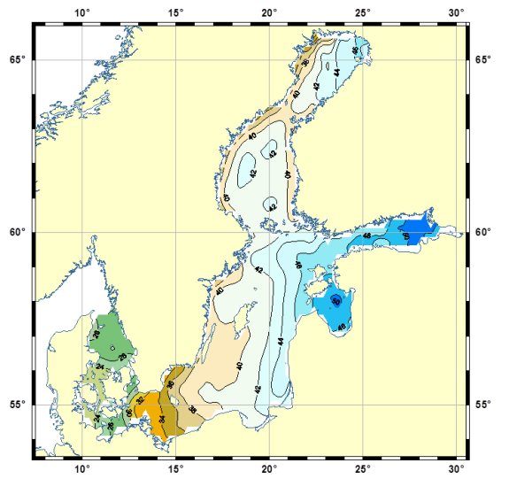
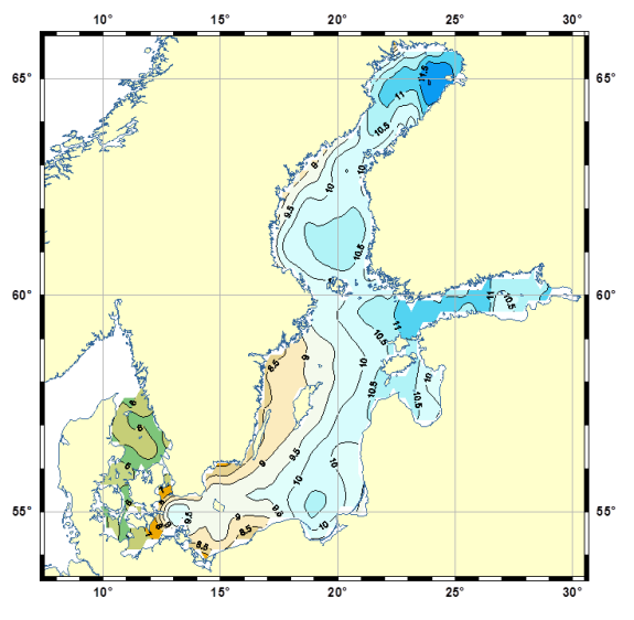
Figure 1. (a, upper) Mean seasonal sea level amplitude (cm) and (b, lower) its standard deviation
Altimetry data of the satellites TOPEX/Poseidon and Jason-1/2 were verified by hourly SHMI (Swedish Meteorological and Hydrological Institute) tide gauge data and monthly data from the PSMSL (Permanent Service for Mean Sea Level) system. The results of the comparative analysis of remote sensing data and tide gauge measurements have shown a correlation coefficient in the range of 0.889–0.969.
Seasonal variability of sea level was analyzed as temporal anomalies at fixed points on the track and in the crossover points of ascending and descending tracks. Maps of the mean seasonal level amplitude and its standard deviations are shown in Figure 1.
The maximum mean seasonal amplitude levels (> 50 cm) are observed in the Gulf of Finland and the Gulf of Riga, which receive the flows from the Neva (runoff 83,5 km3 per year) and Daugava rivers (runoff of 19.7 km3 per year).
The smallest values (< 30 cm) are observed in the Kattegat and the Danish straits. Standard deviations of the seasonal cycle of the sea level amplitude are observed in the Gulf of Finland and the Gulf of Bothnia (> 11 cm), with minimum values (< 8 cm) observed also in the Kattegat and the Danish straits.
For inquiries about this research, please directly refer to the authors.

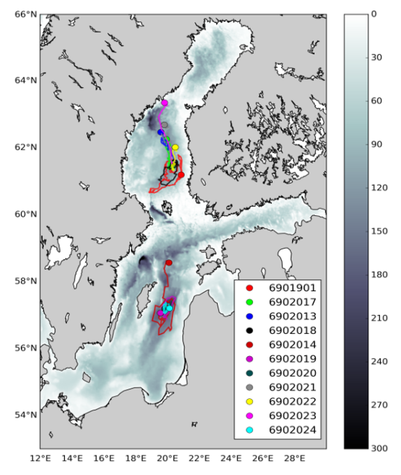
Figure 1. Routes of FMI’s Baltic floats during 2012-2017. Dots indicate the latest position / recovery point of the float. Credit Simo Siiriä (FMI).
by Tero Purokoski (tero.purokoski@fmi.fi) and Simo Siiriä, Finnish Meteorological Institute, Helsinki, Finland
In 2010 the Finnish Meteorological Institute (FMI) decided to test the suitability of Argo-floats for the Baltic Sea. After contacting the float manufacturers it became evident that no-one else at that time was using the floats in the Baltic Sea like environment i.e. in a shallow and low-salinity sea.
In 2011 the first Baltic test dive was performed and in May 2012 one float was deployed into the Gulf of Bothnia in the northern Baltic Sea. The float operated flawlessly until December when it was recovered by a coast guard helicopter.
In 2013 two floats were deployed: one to the Gulf of Bothnia and the other to the central Baltic Sea (i.e. Gotland Deep area). Since that FMI has had continuously at least one float measuring in the Baltic Sea. Both bio-optical and basic (CTD) floats are used. The routes of the floats are shown in map below.
At present FMI has three active floats in the Baltic Sea. One (WMO #6902024) at the Gotland Deep area surfacing weekly and one (WMO #6902023) in the Gulf of Bothnia. That float, nicknamed “Ape1”, is our oldest float and now on its third mission. The first six month mission was in 2012. The second was from May 2014 till November 2015. After each mission it has been serviced and recalibrated at Teledyne Webb Research. Altogether, it has performed almost 500 dives during its lifetime.
The third float was just deployed in the beginning of May to the Gulf of Bothnia. In addition to CTD it has also an oxygen sensor aboard. Our intention is to recover that float in summer 2018.
We will deploy one more float at the end of May into the Bay of Bothnia. It will be the first time that we operate an Argo-float in that northern sea area. Salinity there is very low and there will be ice cover during winter time. Challenging dives ahead!
For inquiries about this research, please directly refer to the authors.
BALTICAPP Wellbeing from the Baltic Sea – applications combining natural science and economics

Figure 1. Causal chain of interactions: from the global drivers of polluting and extractive uses of the marine environment to the societal impacts
by Kari Hyytiäinen, University of Helsinki (kari.hyytiainen@helsinki.fi)
The state of the Baltic Sea serves as an excellent example of a regional environmental problem that can be efficiently controlled by regional mitigation efforts, but which is heavily affected by global developments and megatrends. Such developments include changing climate, urbanization, technological progress and evolution of life styles and consumption patterns.
Climate research community has developed a set of Representative Concentration Pathways (RCPs) and Shared Socioeconomic Pathways (SSPs) that describe a wide range of global climate and socioeconomic outcomes. Combinations of SSPs and RCPs can be associated with technological, socioeconomic, and policy futures that lead to a particular atmospheric greenhouse gas concentration pathway and magnitude of climate change. Downscaled at smaller spatial scales and extending until the end of the ongoing century, such pathways serve also as tools to evaluate the impacts of global developments on regional economies, societies and ecosystems.
How serious challenges may changing climate and changing society provide to marine protection of the Baltic Sea environment? What are the prospects for reaching the Good Environmental Status (GES) in the Baltic Sea under alternative climate and socioeconomic futures? What opportunities would ‘citizen science’ provide to marine research and management? These are types of questions studied by the BONUS BALTICAPP project.
In order to explore the future prospects of protecting marine ecosystems, one needs to establish a causal relationship between the society and environment. We study both of how the extractive and polluting uses of the marine environment affect the aquatic ecosystem, and how the changes in the ecosystem health and performance affect citizens’ opportunities to enjoy from recreation and other marine ecosystems services.
Many of the tools needed for such analysis have been developed by earlier resdevelopment of concrete dearch projects and networks. BONUS ECOSUPPORT developed spatially and temporally detailed marine models to study the impacts of changing climate on the marine environment. BalticSTERN research network developed the tools for the cost-benefit analysis of nutrient abatement. BONUS RECOCA project estimated cost function for load reductions. BONUS BALTICAPP combines existing models and data, fills in the remaining data gaps, and attempts at establishing explicit links between the most important modelling elements.
Such work involves several steps (see Figure 1). The first task is to downscale global climate scenarios at relevant temporal and spatial scales both in the drainage basin and the marine environment. A parallel first task is to extend the shared socioeconomic pathway narratives at the Baltic Sea region. The combined climate and socioeconomic impacts are translated as trajectories of pressures. The second step is to use the projections of drivers and pressures as inputs of the biogeochemical model. The outcomes from biogeochemical model are again used as inputs to food web model. Thereafter the projected biogeochemical fluxes and effects to the marine flora and fauna are interpreted in terms of indicators that reflect changes in the provisioning and cultural ecosystem services. Finally, the changes in the indicators are described in monetary terms when relevant, and with quantitative or qualitative descriptors otherwise.
Another major objective of the BONUS BALTICAPP project is to develop and pilot a citizen science based mobile application. Citizen science is a field where volunteers collect and process data as part of a scientific enquiry. Our aim is to create an online platforms that both serves the general public and, at the same time, collects data on the use of cultural ecosystem services and recreation hotspots. We hope that such dialogue between citizens and scientists could help us to better understand the contribution of the Baltic Sea on human wellbeing.
For inquiries about this research, please directly refer to the authors.
joint issue with the final BALTEX Newsletter No. 16
Drift bottles in the southern Baltic Sea – an experiment-of-opportunity

by Hans von Storch, Ulrich Callies (Hemholtz Zentrum Geesthacht, Institut für Küstenforschung) and Anders Omstedt (University of Gothenburg; Marine Sciences: Oceanography)
A remarkable story about children preparing drift bottles, seamen dropping several of them simultaneously into the Baltic Sea, and others finding them at beaches far from each other. Thus, a formidable empirical data set, namely of the locations of findings spots, was the result of an “experiment-of-opportunity”. Using a transport model, we suggest the mechanism, how this wide spreading happened.
200401.flapo.fva (552 KB)


